![(1788) Plan of Torento [sic] Harbour with the proposed town and part of the settlement, Québec 6th Dec. 1788, Gothermann, Capn. Commandg. Rl. Engrs. Colonial Correspondence Canada (Québec) 1790 no. 47 Plan B](/internal/media/dispatcher/2237612/preview)

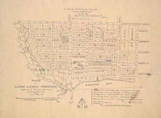
(1788) Plan of Torento [sic] Harbour with the proposed town and part of the settlement, Québec 6th Dec. 1788, Gothermann, Capn. Commandg. Rl. Engrs. Colonial Correspondence Canada (Québec) 1790 no. 47 Plan B
DateApproximately 1908
Names
Mann, Gother, 1747-1830
(cartographer)
Royal Engineers Office (Quebec)
(contributor)
Robertson, J. Ross (John Ross), 1841-1918
(contributor)
FormatMap
NotesApproximately 1908 reproduction of original 1788 map.
Dimensions62.5 cm x 42 cm (24 5/8 in. x 16 9/16 in.)
Scale2 inches = 1 mile
Language
CollectionBaldwin Collection of Canadiana
Usage Rights
Public Domain
(Learn
More)
Object NumberT-1788-2-SMALL
Approximately 1908